The Seljuk Khan of Anatolia
http://www.turkishhan.org/
About this website
Introduction: what is a han?
History of the Seljuks
Life in the Seljuk Han
Seljuk architecture
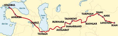
Trade
Architecture and Decoration of the Seljuk Han
Seljuk decorative arts
Resources
Bibliography
Please note that the above details were correct on the day this post was published. To suggest an update, please email the site's editor at tmciolek@ciolek.com
About this website
Introduction: what is a han?
History of the Seljuks
Life in the Seljuk Han
Seljuk architecture
Trade
Architecture and Decoration of the Seljuk Han
Seljuk decorative arts
Resources
Bibliography
Please note that the above details were correct on the day this post was published. To suggest an update, please email the site's editor at tmciolek@ciolek.com
posted by tmciolek at 9:55 AM
0 comments
![]()
![]()