SUGGESTIONS OF NEW ENTRIES and COMMENTS
are always warmly welcome - tmciolek@ciolek.com

28 November 2005

Pilgrimage Routes in North Wales

http://www.peterrobins.co.uk/wales/

A Map + Introduction +Route Details
- Holywell and how to get there
- Chester-Holywell (30km)
- Shrewsbury-Holywell (125km)
- Holywell-Bardsey (200km)
- Holywell-Llandderfel (-St Davids) (60km)
- Pennant Melangell (70km)


Please note that the above details were correct on the day this post was published. To suggest an update, please email the site's editor at tmciolek@ciolek.com

The Roads to Santiago - Walkable Pilgrim Routes

http://www.peterrobins.co.uk/camino/

Routes; Alphabetical list; From Channel ports; Britain: suggestions; Route development; Background; Spain; France; Ober/Niederstrasse; Other pages
Pilgrimage routes

Caminos de Santiago - History - France
The closer you get to Spain, the clearer the link with Compostela, but further away the link is less clear. Arles, for example, will undoubtedly have been a stopping-off point for Italians going to Compostela, but equally it will have been a stopping-off point for travellers from Spain and SW France to Rome. All roads go in two directions.
Pilgrimage routes


Please note that the above details were correct on the day this post was published. To suggest an update, please email the site's editor at tmciolek@ciolek.com

Itineraires Romains en France

http://perso.wanadoo.fr/itineraires-romains-en-france/default.htm
Accueil - Itinéraires antiques, Sources historiques, Ossature du site, Bibliographie
Carte
Voies Romanes
Contact
Liens
Roman roads


Please note that the above details were correct on the day this post was published. To suggest an update, please email the site's editor at tmciolek@ciolek.com

Maritime Archaeology Malaysia

http://www.maritimeasia.ws/

An exhibition of the historic shipwrecks discovered around Malaysia, opened in November 2001 at Muzium Negara in Kuala Lumpur. It has been extended for several years, and there are hopes that it may become the nucleus of a new national maritime museum. A major section, Discovering Asia's ceramic development, draws on seven shipwrecks, spanning half a millennium.
[...]
Exhibition: * Seven shipwrecks; Specific ships: * Tg.Simpang (C10-12); * Turiang (c.1370); * Desaru (c.1845).
Topic pages: * Chronology; * Malaysia; * Ship types; * Iron; * Compass; * Soundings; * Tioman; * 1421 bunkum.


Please note that the above details were correct on the day this post was published. To suggest an update, please email the site's editor at tmciolek@ciolek.com
26 November 2005

Portages: A Simple but Powerful Idea in Economic History

http://web.arch.ox.ac.uk/archatlas/Portages/Portages.htm

Early trading networks carried relatively small quantities of valuable goods, often over considerable distances, both by land and water. The relationship between overland transport and carriage by river or sea helps to explain why trading centres rose to prominence at certain key positions on these routes. With very small quantities of goods, light vessels might be carried over short distances between rivers; and even when the bulk of traded goods increased, it might still be advantageous to carry the goods for short distances overland from one port to another. Sites at such break-of-bulk points became major nodes in the transport network. This presentation explores the changing geometry of early trade-routes, and especially the interface between land and sea.


Please note that the above details were correct on the day this post was published. To suggest an update, please email the site's editor at tmciolek@ciolek.com

The Growth of Global Trade 3500 BC - AD 1500

http://web.arch.ox.ac.uk/archatlas/IndexAAP2.htm

Plotted at 500-year intervals, the successive snapshots used [...] show the proliferation of trade routes which supplied a growing urban network. Beginning with the earliest cities of Mesopotamia, in the fourth millennium BC, a cumulative process of expansion continued down to the present day. Growth was not even, either in space or time; the Persian Gulf network collapsed around 1700 BC, and there was general contraction at the end of the Bronze Age, in the late second millennium BC—followed by very rapid expansion in the early first millennium BC, at the beginning of the Iron Age. Interaction with China, already evident in AD 1, shifted the centre of gravity to the Indian Ocean; until discovery of the New World brought a new importance to the Atlantic coastlands.

Global trade routes


Please note that the above details were correct on the day this post was published. To suggest an update, please email the site's editor at tmciolek@ciolek.com

23 November 2005

FAO Table of Nutritive Factors

http://www.fao.org/es/ess/xxx_p.asp

[commodity] [calories/100 grammes] [protein mg/gramme] [fat mg/gramme]
ALFALFA MEAL 265 305 20
ALMONDS SHELLED 589 200 522
APPLES 48 1 3
APRICOTS 45 13 4
AVOCADOS 119 15 113
BACON PIGS 362 131 341
BANANAS 60 7 3
BARLEY 332 120 18
BARLEY FLOUR AND GRITS 343 92 17
BARLEY PEARL 346 90 14
BEANS DRY 341 221 17
BEANS GREEN 50 30 4
BEEF BONLESS 150 185 79
......


Please note that the above details were correct on the day this post was published. To suggest an update, please email the site's editor at tmciolek@ciolek.com

22 November 2005

Barid, Islamic Postal System

http://www.saudiaramcoworld.com/issue/197604/the.appointed.rounds.htm

Whereas the Pony Express collapsed after 16 months, the barid flourished for centuries and spread to India where Muslim rulers maintained its efficiency—as traveler Ibn Battuta indicated after a trip to Sind in 1333. From the frontier of Sind to Delhi in India, he wrote, is a 50-day march, "but when the intelligence officers write to the Sultan . . . the letter reaches him in five days by the postal service."


Please note that the above details were correct on the day this post was published. To suggest an update, please email the site's editor at tmciolek@ciolek.com

21 November 2005

Postal System in Medieval Bengal

http://banglapedia.search.com.bd/HT/P_0235.htm

"Important contribution in improving the postal system was made during the reign of Mohammed bin Tughlaq (1325-1351). ibn batuta, travelling during his reign recalled that there existed two different kinds of postal system: mounted couriers travelling on horses, and the general couriers on foot. During the Tughlaq period the postal officials also performed some police functions.

The postal system was completely reformed during the reign of Sher Shah (1538-1545), who established a mounted post in Bengal by improving the early dak runner system, and constructed the grand trunk road from sonargaon to the bank of the river Indus covering a distance of 4,800 km. He established sarai-cum-dak chowkis after every two miles at all intervals. According to Abbas Khan Sherwani, author of Tarikh-i-Sher-Shahi, Sher Shah constructed 1,700 post houses employing nearly 3,400 postal messengers and horses."


Please note that the above details were correct on the day this post was published. To suggest an update, please email the site's editor at tmciolek@ciolek.com

18 November 2005

Maritime Spice Routes from South East Asia

http://asiapacificuniverse.com/pkm/spiceroutes.htm

The spice routes


Please note that the above details were correct on the day this post was published. To suggest an update, please email the site's editor at tmciolek@ciolek.com

Salt Route

http://www.ckrumlov.cz/uk/region/histor/t_solste.htm

"In Hallstatt and the surrounding area the mining of the salt deposits started and in the region of the Alps copper-ore was found, which was then processed. The subject of the exchange trade during the Bronze Age was from the southern side - salt and copper - which was transported in round wooden containers "hřivny". From the north, they traded with pewter from the Krušné mountains, Baltic amber, furs and possibly gold. Metallurgical products were bronze as luxurious weapons (daggers), decorative needles, axes and chisels were transported in both directions.

During the Hallstatt-Lateen period other luxurious products from the Mediterranean were imported as well as salt and wine.

From our country we mostly exported iron products, silver and gold from the Šumava gold fields, also wheat, graphite ceramics and others.

During the Roman and Slavonic period, the import broadened by some food stuff, also by decorative and household ceramics and fabrics. Salt remained the most important article of import. Apart from the traditional export items, the export included horses, cattle, furs, skins and also slaves."


Please note that the above details were correct on the day this post was published. To suggest an update, please email the site's editor at tmciolek@ciolek.com

Atlas of the Mughal Empire: Political and Economic Maps

http://www.amazon.com/gp/product/
offer-listing/0195603796/qid=1114483889/sr=1-24/ref=sr_pb_a/
gp/product/offer-listing/0195603796/qid=1114483889/


Atlas of the Mughal Empire: Political and Economic Maps With Detailed Notes, Bibliography, and Index
by Irfan Habib

Edition: Hardcover


Please note that the above details were correct on the day this post was published. To suggest an update, please email the site's editor at tmciolek@ciolek.com

17 November 2005

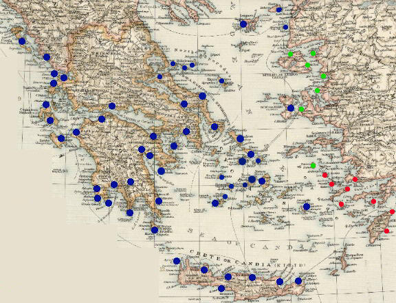
Venetian Fortresses in Greece

http://members.tripod.com/romeartlover/Venezia.html


Venetian Fortresses in Greece

In the Ionian Islands:
Corfù (Kerkyra)
Santa Maura (Lefkadas)
Cefalonia (Kephallonia)
Asso (Assos)
Zante (Zachintos)
Cerigo (Kythera)

In the Greek mainland:
Parga
Preveza and Azio (Aktion)
Vonizza (Vonitsa)
Lepanto (Nafpaktos)
Atene (Athens)

In Morea:
Castel di Morea (Rio), Castel di Rumelia (Antirio) and Patrasso (Patra)
Castel Tornese (Hlemoutsi) and Glarenza
Navarino (Pilo) and Calamata
Modon (Methoni) and Corone (Koroni)
Braccio di Maina, Zarnata, Passavà and Chielefà
Mistrà
Corinto (Korinthos)
Argo (Argos)
Napoli di Romania (Nafplio)
Malvasia (Monemvassia)

In the Aegean Sea:
Negroponte (Chalki)
Castelrosso (Karistos)
Oreo
Schiatto (Skiathos)
Scopello (Skopelos)
Alonisso
Tino (Tinos)
Egina (Aegina)
Nasso (Naxos)
Milo (Milos)
Stampalia (Astipalea)
Scio (Chios)
Lemno (Limnos)
Candia (Kriti)


Please note that the above details were correct on the day this post was published. To suggest an update, please email the site's editor at tmciolek@ciolek.com

16 November 2005

North America, England and the Green Gold (Tobacco) 17th-19th c.

http://www.slaveryinamerica.org/history/hs_es_tobacco_slavery.htm

Virginia Colonial Tobacco Exports

1616 - 2,300 lbs.
1617 - 20,000 lbs.
1618 - 50,000 lbs.
1622 - 60,000 lbs.
1626 - 300,000 lbs.
1639 - 1,500,000 lbs.
1700 - 20,000,000 lbs.
1775 - 100,000,000 lbs.


Please note that the above details were correct on the day this post was published. To suggest an update, please email the site's editor at tmciolek@ciolek.com

Production and Export of North American Cotton 18th-19th c.

http://www.buyandhold.com/bh/en/education/
history/2005/economic_power_4.html


"... to produce a pound of cotton thread it took about 12-14 man days. Compare this to other textiles at the time; six for silk, 2-5 for linen and 1-2 for wool. It was only a matter of time before the clever people, who make life easier for those of us who aren't, came up with some solutions to make cotton more viable."


Please note that the above details were correct on the day this post was published. To suggest an update, please email the site's editor at tmciolek@ciolek.com

Old Assyrian Trade Routes 1880-1740 BC

http://cdli.ucla.edu/Staff/Englund/images/ OldAssyrian/Traderoutes_Roaf113.jpg

Old Assyrian trade routes

A map by Dr Robert K. Englund


Please note that the above details were correct on the day this post was published. To suggest an update, please email the site's editor at tmciolek@ciolek.com

Medieval Cloth Trade in Flanders & Artois

http://www.theotherside.co.uk/tm-heritage/background/medieval-wool.htm

"The cloth towns of Flanders - Bruges, Lille, Bergues, and Arras in Artois - were closely linked with England by the trade in raw wool. The damp island to the north produced excellent fine wool, but lacked the skilled craftsmen to make the finest quality cloth."


Please note that the above details were correct on the day this post was published. To suggest an update, please email the site's editor at tmciolek@ciolek.com

Transhumance Routes in Italy

http://66.102.7.104/search?q=cache:
yxKNWupFoIsJ:www.arkeologi.uu.se/aks/projects/barbro/
transhum.htm+transhumance&hl=en&ie=UTF-8


"Transhumance (changing pasture) occurs [...], where the geographical situation and the difference in climate between mountains and coast has led man to create a mobile, pastoral economy. In the Apennine regions of Italy, the transport of animals often involves long distances: moving the herds from the mountains of Abruzzo to the plains of Apulia usually took a month in each direction. This economy eventually became so profitable that during Roman times the network of drove roads (calles ), virtually became a state within the state and even, from a certain time, constituted a province in the Roman administration. The territory and organisation was controlled by the state and a strictly hierachical labour force, including slaves, was formed.

In contrast to the Roman roads, which were designed and constructed for military ends, the transhumance routes were used for many purposes. The many calles crossing these inland regions brought a continuous flow of men, goods, animals and soldiers."


Please note that the above details were correct on the day this post was published. To suggest an update, please email the site's editor at tmciolek@ciolek.com

14 November 2005

Dyes in History and Archaeology

http://www.chriscooksey.demon.co.uk/dha/jtitles.html

Dyes in History and Archaeology, issues 10-20, online TOCs


Please note that the above details were correct on the day this post was published. To suggest an update, please email the site's editor at tmciolek@ciolek.com

13 November 2005

The Incense Road

http://nabataea.net/Incense1.html

Dan Gibson:
...Pliny the Elder mentioned that the route took 62 days to traverse from one end to the other. Many of these stops were cities or towns while others were simply watering locations or dry encampments in the desert. They averaged between 20 and 25 miles apart...

Stops on the Incense Road: Gaza(Jenysos); Elusa; Ruheiba; Obodat; Wadi Fiqreh; Wadi Arabah; Sela; Rekem, (Petra); Ayl; Gryn; Hawara; Wadi Rumm; Al Uyaynah; Northern Desert Trek; Tayma; Meda'in Saleh; Dedan; Khaybar; Medina; Southern Desert Trek; Najran; Sa'ada; Yathul; Marib (Saba); Timna (Qatraban); Shibam(Hadramaut); Ubar...


Please note that the above details were correct on the day this post was published. To suggest an update, please email the site's editor at tmciolek@ciolek.com

DATASET: Venetian galley-operated trade routes 1400 CE-1530 CE

http://www.ciolek.com/OWTRAD/DATA/tmcXMEm1400.html

79 data points defining eight Venetian galley-operated trade routes across the Black Sea, Mediterranean and the Atlantic coasts of Spain, Portugal, England and Flanders. The eight trade routes are: (1) The unnamed backbone of maritime operations, the Adriatic route (Venice - Corfu and back) active till 1533; (2) 'Flanders' route (Corfu - Palermo - Lisbon - Bruges and back) active till 1533; (3) 'Aigues Mortes' route (Corfu - Palermo - Naples - Aigues Mortes - Valencia and back) active till 1508; (4) 'Barbary' route (Corfu - Syracuse - Tunis - Oran - Almeria and back) active till 1533; (5) 'al trafego' route (one-directional, Corfu - Syracuse - Tunis - Tripoli - Alexandria - Corfu) active approx. 1500?, (6) 'Alexandria' route (Corfu - Candia - Alexandria and back) active approx 1500?; (7) 'Beirut' route (Corfu - Candia - Rhodes - Beirut and back) active approx. 1500?; (8) 'Romania' and Black Sea route (Corfu - Negroponte - Constantinople - Tana and back) active till 1452]

Source:
An untitled map of the eight Venetian galley trade routes linking ports of the Black Sea, Mediterranean and of the European coasts of the Atlantic before the middle of the 15th century. The map is published on pp. 398, together with notes notes on pp. 398 and 404 in: Spufford, Peter. 2002. Power and Profit: The Merchant in Medieval Europe. London: Thames & Hudson.


Please note that the above details were correct on the day this post was published. To suggest an update, please email the site's editor at tmciolek@ciolek.com

DATASET: Trade routes in the Ottoman Empire (1300 CE-1600 CE)

http://www.ciolek.com/OWTRAD/DATA/tmcTRm1300.html

174 data points defining trade routes across the eastern Mediterranean, Southern Europe and Middle East

Source:
A map "Trade routes in the Ottoman Empire", pp. 122-123, in: Inalcik, Halil. 2000. The Ottoman Empire: The Classical Age 1300-1600. London: Phoenix Press. [A paperback edition of a 1973 book]
A map "Trade routes of the Empire", pp. 220-221, in: Inalcik, Halil and Donald Quartet. (eds.). 1997. An Economic and Social History of the Ottoman Empire. Volume One. 1300-1600. Cambridge: Cambridge University Press.


Please note that the above details were correct on the day this post was published. To suggest an update, please email the site's editor at tmciolek@ciolek.com

12 November 2005

A New Proposed Nabatean Trade Route

http://nabataea.net/nroute.html

Dan Gibson:
In his translation of the Xiyu juan, or "Chapter on the Western Regions" from the Hou Han shu, John Hill proposes in his notes (nos. 12.21 and 12.24) that a trade route used to exist between Petra and Wadi Sirhan to the east. Such a trade route would cross the desert to link Petra directly with Jauf, and subsequently to the trade routes that ran east from there to Gerrha or to the ports at the head of the Persian Gulf. This proposed trade route would have provided a direct link between Gerrha and the more northern ports such as Charax Spasinu on the Persian Gulf, and Gaza and Rhinocorura (modern al-'Arish) on the Mediterranean Sea...
... based on Chinese records, John Hill has suggested that a trade route existed between Petra in the west and Gerrha in the East. The part of the route that ran east from Petra to Ail, and then to Ma'an and finally to Jafr is quite acceptable, and follows a natural course of travel between these centers. There is also enough water along this route for major camel caravans to pass. The problem with the suggested route was getting a caravan from Jafr to a spot with water in Wadi Sirhan. Since camels require about 80 - 100 liters of water each, a small caravan of 100 camels would require 8000 - 10,000 liters of water. There had to be a watering point between Jafr and Wadi Sirhan with a minimum of 10,000 liters and, preferably, much more...
nabatean trade route


Please note that the above details were correct on the day this post was published. To suggest an update, please email the site's editor at tmciolek@ciolek.com

Nabataean Trade Routes 1900BC-100AD

http://nabataea.net/trader.html

Dan Gibson:
... because of their low social standing, at least in their early history; they [Nabataeans ] developed their own trade routes and watering systems in the Arabian desert. In the book I also compare them to modern day gypsies and Turkomen who quietly conduct trade in the Middle East to this very day, following the patterns set down by very ancient traders and merchants...
Nabatean trade routes


Please note that the above details were correct on the day this post was published. To suggest an update, please email the site's editor at tmciolek@ciolek.com

10 November 2005

Silk Road Chronology, 5000 BC-1900 AD

http://www.silk-road.com/artl/chrono.shtml

...
1 A.D.
Silk first seen in Rome.
Buddhism begins to spread from India into Central Asia.
Roman Syria develops the technique of blowing glass. The industry expands.
Kushan Empire of Central Asia. Sogdians trading on Silk Route.
Xiongnu raids upset Chinese power in Tarim region.
Death of Jesus Christ. Spread of Christianity begins.
Chinese General Pan Ch'ao defeats Xiongnu and keeps the peace in the Tarim Basin. The stability of the Silkroad popularizes the caravan trades into two routes - north and south.
China sends the first ambassador to Rome from Pan Ch'ao's command, but he fails to reach Rome.
Graeco-Egyptian geographer, Claudius Ptolemy, writes his Geography, attempts to map the Silkroad.
...


Please note that the above details were correct on the day this post was published. To suggest an update, please email the site's editor at tmciolek@ciolek.com

DATASET: Central European pilgrimage routes to Rome (1500 CE)

http://www.ciolek.com/OWTRAD/DATA/tmcDEm1500.html

204 data points defining pilgrimage routes across Denmark, Belgium, Germany, Austria, Poland, Bohemia, Switzerland, and Italy

A map 'Romweg Karte' published in 1500 by Erhard Etzlaub of Nuremberg, reprinted pp. 2, in: Spufford, Peter. 2002. Power and Profit: The Merchant in Medieval Europe. London: Thames & Hudson.


Please note that the above details were correct on the day this post was published. To suggest an update, please email the site's editor at tmciolek@ciolek.com

DATASET: Woollen cloth trade routes

http://www.ciolek.com/OWTRAD/DATA/tmcBEm1100.html

17 data points defining trade routes across Belgium, France, Netherlands and Germany

Source:
An untitled map of woollen cloth trade routes linking Cologne, Bruges and Montreuil between the 12th and 15th century, pp. 233, in: Spufford, Peter. 2002. Power and Profit: The Merchant in Medieval Europe. London: Thames & Hudson.


Please note that the above details were correct on the day this post was published. To suggest an update, please email the site's editor at tmciolek@ciolek.com

08 November 2005

DATASET: French pilgrimage routes from 1000 CE till 1500 CE - dataset 2

http://www.ciolek.com/OWTRAD/DATA/tmcFRm1500a.html

58 data points defining major mediaeval pilgrimage routes across France to Santiago de Compostela

Source:
Map 'Principal centres and routes of Northern Spain and France.' pp. 178-179, in Sumption, Jonathan. 2002. Pilgrimage: An Image of Mediaeval Religion. London: Faber and Faber Ltd.


Please note that the above details were correct on the day this post was published. To suggest an update, please email the site's editor at tmciolek@ciolek.com